|
Foggy
Paddling a Loosing Experience Gail Ferris |
|
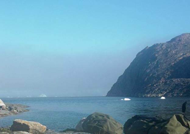
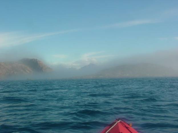
This is the approximate view of the fog over the
icebergs outside the passage near Innarsuit that I was camping in. This picture was taken before I unpacked my
kayak. On the right is the opposite side of the passage. |
|
01 |
|
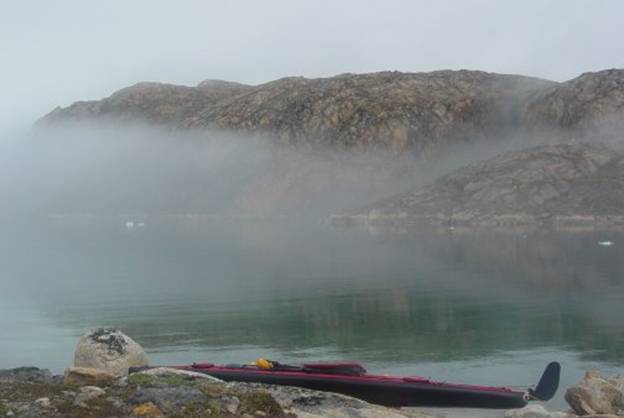
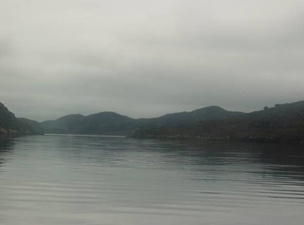
The next morning The picture below is not quite at that moment but
you can see my kayak as it is situated outside my tent up on the rocks above
the tide line and the fog blowing in from the outside to the west. The fog I paddled in was much denser having fifty
feet of visibility. |
|
02 |
|
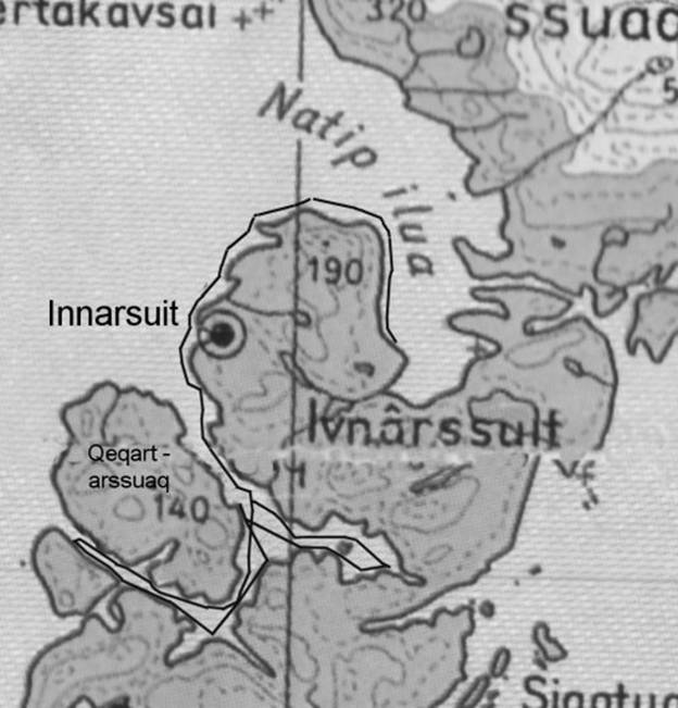
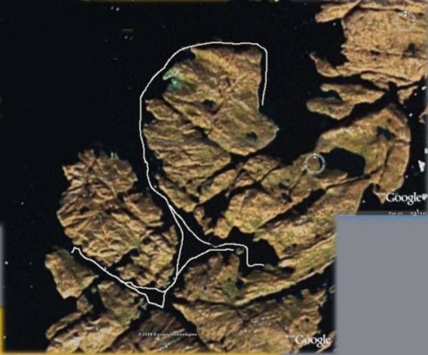
I am glad that I paddled the 1.7 mile crossing
yesterday to At I was bored so I decided to take a chance. I started out at about This passage is well defined being flanked with
vertical rock cliffs and few pockets.
It begins at Innarsuit and leads eastward toward the tiny town called
Naujat. I thought it would be probably safe to paddle along
in the fog. |
|
03 |
|
I brought my magnetic compass and GPS. As I was making the crossing I thought to myself I
wonder if I should paddle down to the peninsula on the opening and leave a
few marker rocks so that I know that this peninsula leads directly up to my
tent a few hundred feet away. I decided leaving marker rocks as a rather futile
idea surely I would not become that confused in this fog. I decided to just head directly across northward
from camp make the crossing the 650 foot wide passage to the small island, Qeqartarssuaq. I was essentially just following around the south,
east and up the north side in a U shaped route hugging the rocks. I headed along the south side of the island to its
eastern tip for a mile. I just paddled
next to the rocks because I could not see more than a few hundred feet. The fog was not too cold because it was not coming
from the ice but rather from the warm water to the west, Then I paddled along the eastern edge for half a mile
and up just a quarter mile at most the north side of the island. All looked familiar relatively speaking and if it
did not I convinced myself that I had to be near a cove that was loaded with
shellfish and moving northward to a cove without shellfish. |
|
04 |
|
I figured that I could just cross over heading
pretty much due north and surely I would hit the south facing coastal portion
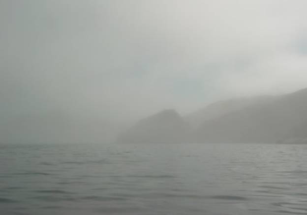
of Innarssuit Island on the opposite side. The crossing was only 2 tenths of a mile
and when I was partway across I could see the upper portions of the cliffs on
Innarssuit because the fog was an even color grey
and not all that dense. I stuck to following the rock walls for what seemed
like a very long time passing each unfamiliar cove indentation inlet
peninsula for the next 1.7 miles until I reached Innarssuit. Even though I had paddled several times to Innarsuit
I had always paddled on a bright sunny day a quarter mile or so offshore so I
had never really familiarized myself with this very different type of
detailed paddling along this coast.
Previously I was much more interested in exploring all the
indentations on the opposite side. I
was really unfamiliar with this coast up close. I did not think it mattered then. It was nice to reach something definite, Innarssuit, because I was getting somewhat concerned as
to what was real. I paddled along the vague western coast not
completely sure but I knew I could only be heading around to and along the
south side of Natip Ilua passage. |
|
I paddled along heading eastward down the passage
until I got bored because everything just looked all the same there was no
change in the topography. I decided
that it was pointless and just too boring paddling in all this bland grey
fog, so I turned around. On my way back following along the vertical rock
cliffs of the passage was fine but looking out from the peninsula I was
rounding - something was not quite right.
Sure I was perfectly safe following the rock walls I had been there
before. I knew that there were no mysterious hidden passages
along these escarpments but then again looking out over the water; things
were looking a little fuzzy. “But that is okey I can find my way back. All I have to do is just follow the rocks
back around and I will be home” I said to myself. |
|
Then I noticed what was a very familiar little
island in the bright sun which had particularly distinctive shellfish loaded
shallows but this shore looked somewhat questionable in this fog. I asked myself “is that really that island or is
this some other island?” On my map that island was not even there. “Oh well not to worry, after all, that
island really is just a few rocks with a tidal rip washing over the
shallows.” I continued paddling hugging the rocks I heard some
dogs so I knew I could only be near Innarssuit again
it was the same dogs that had barked at me before so that was okey. |
|
Then I crossed Innarssuit
bay and headed along the rocks now on the south side of the town. I went from bay to bay losing sense of
direction just hugging the rocks not knowing which bay which, gradually
heading eastward. I could not tell if
I was dipping into a large or a small bay.
All I knew was that I was just heading along the rocks and that I had
to keep the sun on my right side as I headed eastward. Thoughts came to mind that I had not bothered to
keep track of the time or the direction when making crossings or from point
to point. Other people do that, not
me. I had my GPS with me but I had never bothered
considering that it might be a good idea to learn how to do things such as
use the “Go To” point system. All I
learned to do, out of necessity, was to take way points for my records. |
|
05 |
|
I never considered that it might be a good idea to
learn how to use the “Go To” function with the waypoints. As far as the waypoints are concerned it is
important to know which waypoint is which because they all look the same on a
monitor that does not show any sort of map.
To compensate for not having any map I must gather current waypoints on
my way out so that I could know which waypoint I would like to “Go To” on the
way back. Nothing like a foggy paddler paddling in the
fog! That was me and there I was
getting more and more in trouble, I convinced myself “how could I get in trouble? If
worse came to worse would be that I would just follow the rock walls around
and surely I would get back to my tent.
After all, I was just paddling around a U I could
either follow the outside of the inside of the U. The shortest way would be to cross over
from the outside to the inside of the U and then back again to the outside of
the U where my tent was located.” So here I was gingerly paddling along the rocks
occasionally looking south which ought to someplace be a good spot to cross
from, trying to figure out where I
ought to begin my crossing. Fine I thought but when? “This does not look too good! Looks like open water over there! I am not crossing that only to wind up out
in the open water.” Little did I realize that the fog had created this
aura of brilliant brightness over the water. |
|
The innocent fog had become a fifty foot high
brilliant glow just over the water topped with a ceiling of grey fog. This even brilliant glow of white spread
out evenly over the water as I looked south was reflection into the fog of
sunlight from the water. I did not see this glow when I looked north except
over a few icebergs and in this situation the glow was an even arc shrouding
an iceberg which was also this same type of light reflection. Where I could have been making the crossing of a
mere half a mile all I saw was this glowing fog. It seemed impossible to me that I was just
seeing reflection and behind it was actually the island. I could not imagine the island appearing as
anything other than grey fog in front of the dark rock-cliffed
island, Qeqertarssuaq. “Surely the brilliant glow can only be coming from
open water” I told myself as I continued paddling eastward down the coast for
an inordinately long time. |
|
Finally I decided I ought to cross. What a great idea that was! So there I am paddling across so I thought
and next thing I come upon is this island.
I consoled myself thinking it was a little island off
Qeqertarssuaq. “How lovely” I thought
“now all I have to do is just keep following the curve of this island I think
I remember, but who knows anything is possible, maybe it is one of those
peninsulas that is only connected at low tide. Oh well, the sun is on my right side, so
that is alright.” I gingerly kept paddling until I saw a fish drying
rack on my right that I had seen on a previous day’s paddle and it was only
in one place because there was only one fish rack like that anywhere around. Oh no! Guess where the fish rack was I said to
myself? That fish rack is down in the
bottom of the north eastern wing of the passage and it is sitting on Oops well here I am and it is definite I said to
myself and I am glad I have been here before. |
|
06 |
|
Okay I told my self this is easy now all I have to
do is turn around follow this wall out to the end of the passage back west
until I get to the opening where I can cross from the east side to the west
side of the bottom of the “U”. Oh there is that inexplicable island again. Now I know.
That is the island where there were dogs and remnants from
people. How interesting that I never
noticed the dogs that I have just passed by on my way into the bottom of this
passage. It is interesting what you
don’t see unless you are expecting to see.
There is nothing like being a little confused in the fog. I realized how very foolish it had been that I
assumed all this time that I would be perfectly safe paddling along the rocks
so I never bothered with taking any salient waypoints nor kept track of
time. I told myself “Now I will just follow this wall
until I think I am getting to the intersection where I can cross over to Well I crossed the intersection and in the fog I
found that the sun was on the wrong side, my left side which was impossible
unless I was now paddling up the north side of In frustration because I did not want to admit
anything was wrong I just kept paddling telling myself to just keep going and
that things would work out. It is
amazing how irrational you can be when you are scared and confused. I gave up on the compass because the magnetic
compass was 45 degrees off and I did not trust it and the compass on the GPS
was fine but I was just too mixed up because I had no sense of time or
distance while I have been trying to follow this U. And sure enough I came upon an orange net float tied
off at the opening of a little harbour and inside was a lone fishing
boat. Of course that harbor I had seen
before and it could be only one place.
It was on the north side of “Oh boy here I go again” I said to myself. This can only be the little harbor that I
saw last time and this on the north side of the big Luckily as I was retracing my paddling knowing that
I was definitely paddling along the east side of |
|
“Wow the sun came
out. How weird. Whew I recognize where I
am but I would have never guessed that I am at this intersection. Okey, I am really tired
of all this confusion. To be extra
safe I will take the most conservative route.
I will paddle across to There is only one
possible confusing spot which is a very short hop over another opening. That opening I know very well because it
opens to a round area and has a narrow ten foot wide restriction in the end
of it, should I get lost again. I will cross over.” “Okey, I did that. Now I will just paddle up the coast line of
the little unnamed island my tent is on and I should be okey. Well where is that tent
I thought to myself it ought to be anywhere along here. Maybe I am lost again because it is taking
a very long time to find my tent. |
|
Oh this looks like the
peninsula with the rocks on it but where is my tent. Oh! oh this is not
good. Oh I know there are two
peninsulas and this is the first one the next one is where my tent really is. Whew there it is.” |
|
07 |
|
Getting lost in the fog
is not fun but it is great for an adrenalin rush. I have to learn how to
use the Go To function on my GPS and take salient waypoints all along the way
if I want to ever find my way back to my tent in the fog. |
|
07 |
|
|