|
Being Followed by Fjord Cod, The Wonders of Wandering About
in a Kayak in Gail
Ferris |
|
I had not
thought much about the fact that global warming has an effect on glaciers by
speeding up their delivery of icebergs into the water. The increased melt water beneath the
glacier acts like a lubricant making the glaciers calve off icebergs much
faster. In 2008,
once again there I was in Upernavik Greenland where there are several active glaciers. I
blithely thought that that global warming would not have much of an effect on
me. All I was going to do was to go
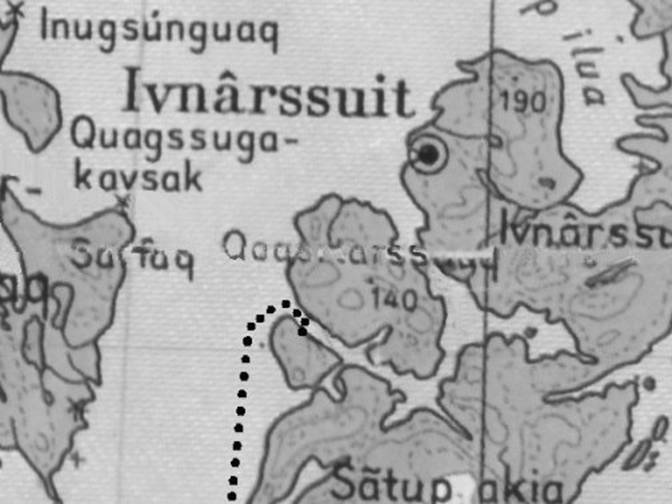
paddling in my kayak across the icefjord and up north of Innarsuit. I assumed that I could just paddle or be
shuttled by motorboat straight across the icefjord. The
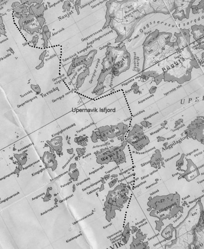
Upernavik icefjord is seven to four miles wide. My experience since 1992 was that the
icefjord always had random icebergs here and there but that there was no lack
of open water. I did not
have any problem in 2005 when I camped next to the icefjord and crossed
it. Then I only encountered just a few
icebergs but no concentration of icebergs great enough to be concerned about
paddling among in my kayak. |
|
01
Followed |
|
Coming
into Upernavik via airplane I looked out the window on the landing approach
and noticed that there was a huge conglomeration of icebergs somewhere out
there. Then from the airport on top of
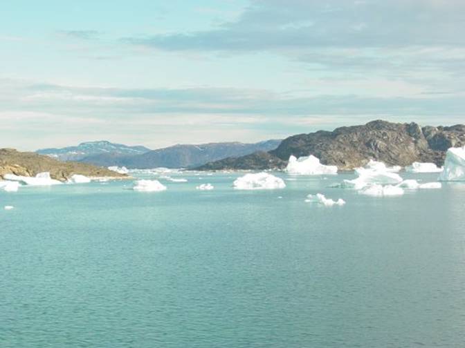
The photo
below was taken in 2003 of Upernavik Isfjord from the airport of that general
view toward Aappilattoq and |
|
02
Followed |
|
I figured
it would be easier, as I had done in 2005, to hire David Thorliefsen with his
motorboat to take me across the Upernavik Icefjord to In the
photo above Puguta is just behind the center island to the right. Launching
from Upernavik is not all that easy for me and I had done this all too many
times before as I find it a little nerve wracking to find people standing
over my shoulder as I put on the dog and pony show while I go through the
ordeal of putting my kayak together and packing it. I would rather go to an island set up my
tent, leisurely put the kayak together and launch when I felt like it |
|
Starting
out from Upernavik all seemed just fine as I put all of my equipment – tent,
camping gear and folding kayak into his motorboat along with David’s family. In the
photo below is taken in 2005 looking north from Upernavik harbor is where we
launched from. In the center is a
motorboat similar to the boat we used.
Far away
is some ice in the icefjord and among the islands. Upernavik is about five miles south of from
the icefjord. |
|
03
Followed 2008 journey to Innarsuit camp |
|
Just a
few short miles away among the islands on the edge of the icefjord, we
started to see a number of icebergs, more than usual. Then on
our way closer we started to notice that we had to alter our route to avoid
the clustered icebergs. David resorted
to taking in a very narrow passage between two tall rocky islands where the
icebergs could not accumulate in enough density to bare our passage. The
narrow vertical passage between the islands, Qagsee
and Natsisat, echoed like the inside of a cave as
water dripped from the rocks and icebergs. A couple icebergs nearly plugged the
passage but we edged by them. We
emerged from the passage and wove our way across the fjord. It was very difficult dangerous
motorboating because only an expert Greenlander familiar with getting through
icebergs surrounded with ice chunks could safely figure out how to get us
through without damaging the hull or the engine accomplish. We had
some scary moments and some tough judgement calls as David decided how to get
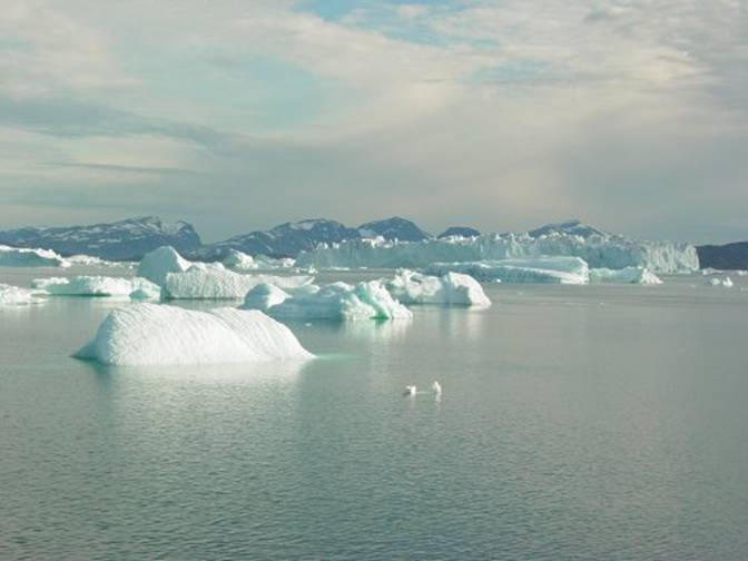
us through. At first
we broke out into a corral of ice similar to the photo below taken in 2005
but then the ice became even denser. |
|
04
Followed Upernavik 2005 1968 |
|
We had a
moment when we were among an expanse of sizeable chips of ice ranging from
half a foot to three feet, something not to hit with a motorboat. We were terrified sitting there debating
how to get through when we heard a berg too close to our boat make a deep
boom signifying that it was about to break apart. I looked
at Emilia, David’s wife, and expressed how I am
afraid of these icebergs by slapping my arm across my chest to show how
terrified I really was. She said the
same thing in the next moment. We were
both scared. What if
we accidentally rammed a chunk of ice in such away that we put a hole in the
boat hull? What if we were trapped in
the ice and could not get out? What if
we damaged the motor and could not get away from the ice? It was cold very cold because we were among
the ice and we were scared. As we got
near to Getting
trapped by ice while on shore is called drying out. In 1994
when I was in I had
that experience several times in |
|
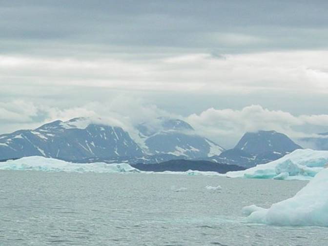
On the
north side of the Upernavik icefjord we saw ice everywhere. I knew from all my past experience that
this was unusual to be seeing this ice, especially so much ice. In front
of us motoring northward we encountered more and more ice. Icebergs were everywhere with no expanse of
open water between them. Lots of chips
of ice spread about on the water from icebergs breaking apart. Icebergs were not all that large but they
were cracking and breaking up, typical of icebergs in the late summer, July
and August. I decided
that Puguta and the area was impossible and we ought
to head west and then north to Naujat.
Maybe there we would find less ice. Naujat
was a tiny settlement I had wanted to visit, having never been there before. As we
neared Naujat I could see that there was just as much ice and that this ice
was the typical, more threatening sort of tall icebergs typical of the Kangerdlugssuaq, Nunatakavsaup
and Alangorssup glaciers to the north. I told
David that we would have to motor to |
|
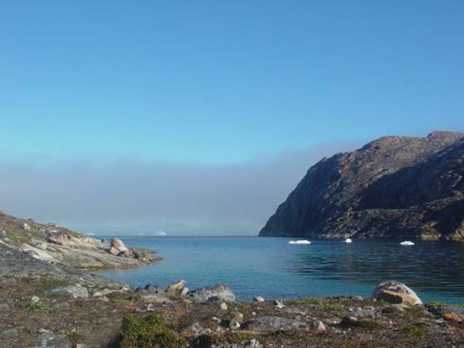
05
Followed campsite 2008 |
|
This was
a protected passage where I knew water was available a very precious scarce
commodity not available elsewhere to my knowledge in the area. The area was protected from the icebergs
because it was a U shaped quarter mile wide passage where wind and current
would unlikely carry any icebergs. My
campsite was on the way to the settlement Innarsuit, so people would pass by
on the outside and on the inside on their way back and forth to Innarsuit. This would offer me safety with the
opportunity to be on flat ground protected from most of the weather and fog
on the more open water to the west. |
|
06
Followed looking out |
|
“Whew was
I lucky I knew of this place I thought to myself but now that I am here what
am I going to do for paddling?” David
dropped me off and was glad to be headed back to Upernavik, now 21 miles away
and across a wider portion of Upernavik Icefjord. I set up
my tent and leered out of the doorway gawking at all those icebergs out there
and the fog that was just starting to show on the open water. Yes sure enough the fog was at first going
back and forth but then it began building up so that only the tops of some of
the larger icebergs were peeking out – how ominous. At least it was a pretty purple color and
the water was blue-gray
with a blue sky above. I could
just relax for now in my nice tent, eat, doze, think about nothing and listen
to the snow buntings chibbering about the hillside behind me. |
|
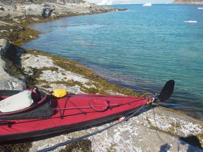
The next
day I put my kayak together. The kayak
was just fine, so now there I was without any doubts or excuses committed to
doing some sort of paddling. I asked
myself “What shall I do for paddling now that I know for sure that I cannot
paddle in my old style of paddling which was to paddle miles and miles
relocating my campsite from place to place because there is just too much ice
everywhere?” “As I
look out of my tent I see icebergs floating past on the outside passage. I really do not want to play with them or get
lost in the fog among them.“ “They are
too big to play “beat the berg” with in my kayak because I cannot race by
them anywhere near as fast as I could if I were in a motorboat. In my kayak I am limited to only paddling
at 3 to 4 knots while the berg I am trying to race past can be moving along
on what can be a 7 knot current or being pushed along by the wind.” Another nasty thought is “What I do if a berg decided to
break up right near me I cannot escape its explosion of ice across the water
or the steep waves it will make.” Next
question is where in this region would there be any water. The last time I camped on an island to the
north I had to trap water flowing over a rock drop by drop. Waiting for a chunk of ice to melt on the
beach in some sort of container is a very slow process. Melting ice wastes my very limited stove
fuel. |
|
Then I
started thinking to myself “I shall do detailed paddling because here is a
unique opportunity to just see things from my kayak in as great a detail as I
wish. I do not have to rush anywhere.” After all
I asked myself “How much do I actually get to see when I am rushing about when
I what I am really interested in doing is exploring, seeing things I have
never seen before - especially little things and things in detail. I need to do slow paddling. Slow paddling will be much more rewarding
because I can stop and look down in the water, up at the cliffs and into the
sky noticing any details I can see and thinking about why they are there.” |
|
07
Followed kayak |
|
On this
journey I will have plenty of time to think about what I see as I am out and
about. If I had an unanswered
curiosity I could just hop in my kayak on another afternoon to go revisit the
place I was curious about. I could
take more pictures and video shots to answer my questions. That is my goal for this trip” In this
new way of paddling, what fun I have because I could just float along, think
about what I am viewing and just look.
This technique amounts to what could be called “detail paddling”. My focus was to paddle each afternoon not
necessarily very far, but with the goal in mind to find new things in the
water, the air or anywhere that I have never seen before. |
|
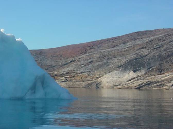
08
Followed berg in passage |
|
“Ah such fun
how great a relief it not to have expend all sorts of energy and adrenaline
by forcing myself to rushed paddling just so that I will be somewhere before
I run out of energy from shear physical and mental exhaustion.” I said to
myself. “No wonder I see so little
when I paddle rushing around too anxious about getting to another campsite
that I do not know is where to start with not daring to risk the time to stop
and look.” It was a
sunny lovely day as I started out from my campsite padding south-eastward
down the passage looking at the snow-covered 1000 foot mountains on
Qagsserssuaq peninsula. These
mountains were just as high as Sanderson’s Hope which is another very
unforgettable landmark near Upernavik. At the
end of the island just a few hundred yards away I turned southwest heading
out through the passage that ended in the open water. This was
a small circular area rock cliff faces on the east side of what is |
|
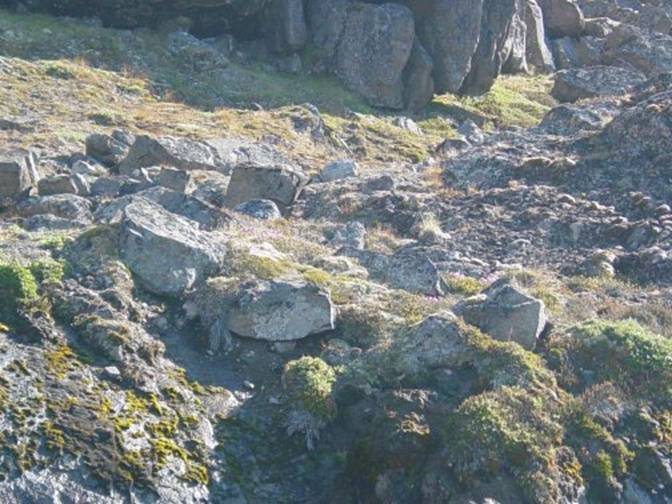
At the
eastern tip was a somewhat flat area that showed rich dirt on somewhat level
ground with willows rooted in what were originally the walls of sod
houses. I suspect
that people had dwelt right there on this corner in ages past because this
corner is ideally protected from the winds on the open water and it is
relatively easy to get up off the water onto for people arriving via umiaqs,
kayaks and dogsleds. It was a good
lookout for all around as well another very important factor for the hunters.
Whenever
I have ever stayed with an Inuit hunter I have noticed that a hunter is
always looking out over the water for birds, ducks, seals, walrus or
whales. Their whole life is dependent
upon any animal that can be hunted for in the form of food and materials. The east side was flanked
with endless, bare, dark brown, fine-textured granitic stone rising from the
water straight up a hundred feet of rounded shapes punctuated with
crevasses. In other words this east
side had absolutely no plants just stone going straight up completely hostile
in character from the west side that had some flatter areas with plants, soil
and sod house wall remains. |
|
09
Followed house remains |
|
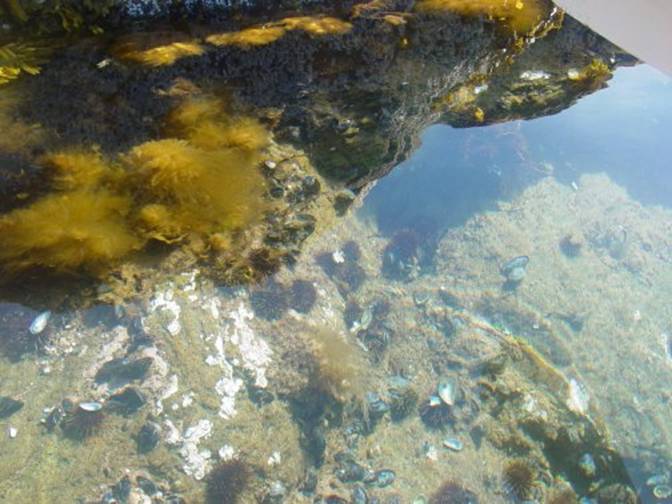
As I turned the corner paddling along the east facing
wall I noticed that there were plenty of sea urchins, mussels and seaweeds on
the shallow bottom. |
|
10
Followed mussels urchins |
|
I was delighted with
seeing all these sea urchins and mussels on the bottom. Then I paddled along the east
wall which was mostly a straight line out to the opening
at the end of the passage. What fun
there it was the opening I was never really sure about from what I could see
on the map. Now I knew that I was
camping on an island, an unnamed island at that. From the outside to the west I had paddled right by
it never seeing it. It was one of
those microscopic paddling situations calling for me to dip in and out of
even the tiniest indentations all along the way. From the outside this opening looked like
nothing. I couldn’t imagine anyone other
than someone very familiar with this area running passage with a motorboat
because It was very shallow about three to four feet deep and narrow, just only ten feet wide. I poked outside the passage narrows just to see it
all and then I turned around. I
figured I would run that area another day.
Today I wanted to closely look at this little interior area before the
restriction. Just after I turned around following along on the
opposite west facing side just near the opening I happened to see in the shallow water a large sea scallop with dark blood red shell
and tentacles its shell was 6 inches diameter anchored among the
seaweeds. Next I saw a few six inch
diameter sea anemones with tan dark-red tipped tentacles. These looked just like the anemones I had
seen off the islands just east of Upernavik in a shellfish rich area. I also think that I saw some sea cucumbers
embedded in the soft bottom. All these
biota told me that the water is very rich here and the salinity is close to
open-water salinity of 32 ppt. Sorry I
forgot to take a picture. |
|
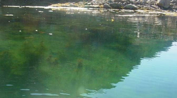
Now that I have seen
these creatures I thought to myself that I ought to just paddle around on the
semicircle shaped eastern side of the passage. “Who knows what I will see” I said to
myself. Here inside there was an
especially rare ideal viewing the bottom situation. The water surface was absolutely flat calm
and the clear sun light allowed me to see the bottom perfectly and from my many
moments on the water in the past in this area, such conditions are not all
that common either the water is too deep or it is disturbed or it is
overcast. So, to take advantage of
this rare situation for viewing the bottom with the least disturbance, I
paddled as lightly as possible so that I would just glide over the surface
and used my rudder to direct my semicircular path along the eastern
wall. I propelled my kayak as
minimally as possible with my paddle just fast enough to glide over the
surface disturbing it as little as possible because I wanted to be able to
look straight down over the side without any riffles disturbing my view or
alarming those who were residing below. |
|
11 Followed
bottom edge |
|
So gently, ever so
gently, just as if I was tiptoeing in my kayak I paddled along with my
cameras at the ready in my lap, for who knows what I would see. And very lightly I directed myself with my
foot operated rudder just enough to keep me from grazing the occasional rocks
just beneath the surface here and there or colliding with the rock walls. I know what you are
thinking, “who ever heard of tiptoeing along in a kayak, now really, what is
this all about?” But really all I
wanted to do was to be able see the bottom because after noticing those
really unusual sea scallops and sea anemones I was excited. I had seen sea scallop
shells on the bottom just once before years ago in Upernavik but never have I
seen them actually alive before. I can tell you that there
are just too many times have I foolishly disturbed the water just enough to
ruin my viewing. |
|
12
Followed bottom |
|
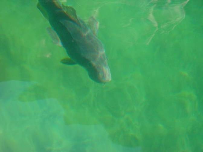
So there I was gliding
along ever so effortlessly and I looked down to see a fjord cod just hanging
in an open circle of seaweed. Then I
saw some more cod below in 5 foot deep water.
Wow how nice! I have not seen
fjord cod for years. The last time was
in 1993. I told myself that I will
just glide along so as not to frighten them in anyway because the last thing
I want to do is loose this moment. Next thing I knew about
six fjord cod were swimming toward me in great curiosity like I was some
playmate. They were adults between one
and two feet long. What a delightful
experience I could not believe my eyes as I found myself being followed about
by this group of codfish. |
|
13
Followed Fjord Cod |
|
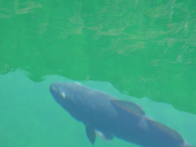
I barely dared to paddle
at all, lest I frighten them away. As
I floated ever so gently along I took still pictures and video footage over
the side as quietly and with at least as little motion as possible not even
daring to look through the viewfinder.
I just roughly aimed and clicked pictures and grabbed video
footage. The cod and I had such
wonderful time looking at each other, what a thrill. I never thought that cod could be so
curious. I wonder if I will ever
have a moment like this again, it was such fun. |
|
14
Followed Fjord Cod |
|
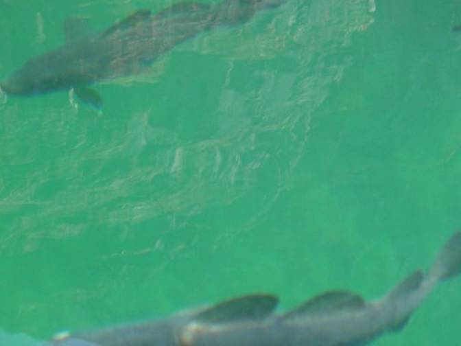
I have had fun with
sculpins, called Ulk in They followed me some
fifteen to twenty feet before they left off and returned to their
hideaways among the seaweeds. |
|
15
Followed Fjord Cod |
|
It is moments like this
that makes all the effort of going all this way to Gail Ferris gaileferris@hotmail.com |