Kullorsuaq Greenland
Weather, Clouds, Colors and Kayaks
Gail
E. Ferris
June
1995 through February 1996
gaileferris@hotmail.com
http://www.nkhorizons.com/index.html
July
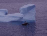
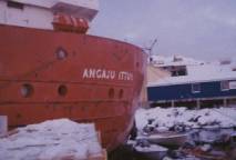
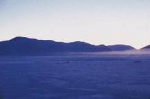
17th I left from Upernavik at noon for Kullorsuaq aboard the Angaju Ittuk the
barometric pressure was 1022 and the barometric pressure had been a straight
line on my graph for the last 24 hours.
The ceiling was at medium height over 3,400 foot peak, Sanderson's Hope
To the east there were wave shaped altocumulus
upward blown clouds. I felt a pressure
change and saw some altocumulus clouds.
At 20:00 the pressure dropped to 1019 mb. The sky to the north appears to have lower cloud density however
there are orographic clouds to the east which suggests strong winds in the alto
air level.
On July 18 the barometric pressure
had been at 1017 mb for the last 24 hrs.
I
arrived via the faster ferry, the Argaju Ittuk, on Tuesday morning at 03:00.
This
coastal ferry, the Argaju Ittuk arrived early at Kullorsuaq although it had been expected to take 18
hours. The ferry did not have that much
to drop at the various settlements on the way north.
We had stopped at Ignarsuit, Tsausaq and
Nuusuaq.
Adam
Grimm suggested to me that I should visit his grandfather Ben Friersen at
Nuusuaq. However I did not wish to risk
getting off the ferry and not getting back to it before it sailed again. They are very good on the ferry at telling
you one thing and doing something entirely different.
We
stopped at Tsaussaq where they said that they planned to be there for one hour,
well guess what? They left in 40
minutes. Lovely - only in the north
Greenland do things go like this.
I was advised by Pauline Knudsen the
director of Upernavik Museum and niece of Samuel Knudsen in Kangersuatsiaq to
visit Regitze Margrete Søby at
Kullorsuaq an eminent eskimologist. www.hum.ku.dk/eskimo/specialer.html
On the way I saw a few familiar
faces here and there it is always this way in the north. I was traveling with a fellow I had met at
Upernavik, Finnur Petersen, who works for the Commune with Jonhardt
Jacobsen. He is from Faroe Islands and
hopes to be working here for a few years.
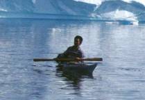
I
met Jonhardt in 1993 and had him take the picture I have of myself paddling
among the icebergs off Upernavik. We
were great friends and unfortunately he has passed away in the last few years.
.As I was riding on the ferry I
discussed this with Hans Nielsen, a teacher fluent in English, who was
returning from Denmark. Hans kindly
introduced me to Sven Nielsen.
Sven Nielsen is the school director
and was a great help to me throughout my stay of eight months in
Kullorsuaq.
A few days later I had an exciting
time talking with Finnur Petersen and Stig Hermansen about the technology
available for measuring three-dimensional areas with photogrametry. This method I hoped to measure kayaks with.
|
|
|
Nikolaj
Jensen with his son, Hans Jetta Bang
photo 1956 |

I had come to visit and discuss
kayak design with Nikolaj Jensen who is an exceptional hunter and kayak
builder.
On the next day Wednesday, July 19,
1995 although I did not have an interpreter I did visit Nikolaj Jensen because
I had been told that he is a most extraordinary kayak builder. I communicated my interest in kayak design
by sitting on the floor demonstrating kayak paddling and showing him some of
the measurements that I was interested in obtaining.
On the following day Thursday July
20th, I again visited Nikolaj Jensen with Sven Nielsen as an interpreter. I had specially chosen Sven for this type of
interpretation because he knows how to paddle and build the kayak. Sven is married to one of Nikolaj's
daughters.
Nikolaj shared with me several
extremely important aspects of kayak and paddle design. the length of the loom is slightly greater than the width of the
kayak it is the width of the kayak and the knuckles of the closed hand. so that
the paddler has enough room to paddle with a stroke that extends the paddler's
arm of the opposite side ending at the hand at the waist of the paddler. I saw this exact stroke at Innarsuit
demonstrated by Jens Eliasen. Nikolaj
was quick to say that this stroke is only used on calm water and I immediately
agreed that when the water is rough a much shorter stroke is best.
The circumference of the loom is not
measured with the thumb and index fingers meeting rather it is measured by the
thumb and index finger including an opening of about 2 cm to allow the
thickness loom to have sufficient strength.
He mentioned that it is very important for the cross section of the
paddle is a diamond or rhombus, which means that the paddle has a rib. He greatly prefers to make his paddles
thicker than many of the other paddles I have seen in this area so that the
paddle is strong.
Therefore the paddle should have a
rib down the middle of the blade so that the paddle will not flutter in the
water, especially during the initial moments of hard paddling to accelerate the
kayak. He makes the loom rectangular
but does not make it thicker on the flat blade side he makes it thicker on the
cross section side this is the opposite of all the paddles I have seen
elsewhere. The loom is carved where the
blade starts with a 45 angle as a step up. I carefully measured one paddle used by Nathanial, which had a
distinct rib and another paddle used by Lars, which happened not to have such a
distinct rib.
The paddle length is determined by
the combination of the length of the loom and the blade the loom at the left
side the blade out to the right side ending with the arm extended out on a
30 angle the hand out flat. I'm
not sure at all about this and to try to better understand this I had Lars
measured.
I was to be rewarded at long last
after all the innumerable challenges and considerable financial sacrifice that
I had made to come to this last northern settlement. This settlement, Kullorsuaq, is where the Greenland kayak is
truly used only for hunting. Now I was
able to obtain kayak design information, which I had come to Greenland
for. I had initially planned to come to
Greenland in pursuit of this information in 1990 during my visit to Barrow
Alaska. At Barrow I discovered that the
kayak had been last used twenty years earlier.
The kayak I had seen at Barrow was only designed to be used for
retrieval of waterfowl it was not at all similar to an open water kayak.
Sven translated to me as Nikolaj
discussed the characteristics his design of one of his especially fast
kayaks. His son, Lars Jensen paddles
this kayak for hunting narwhals and in races.
This kayak is a blue vinyl covered
kayak and although I did not weigh it.
But when I hefted one end of it I found that it was surprisingly
heavy. I do not know just exactly why
these wood frame kayaks are so heavy but it had to weigh more than 50 pounds.
Sven pointed out the kayak Lars
Jensen used and where the kayak paddles were located but on the next day when I
came to measure the Lars kayak Nikolaj directed me to measure Nathanial's
kayak. Nathanial's kayak was a white
kayak white paint over blue vinyl.
Nathanial's kayak had the chins set so that it is a
flatter broader kayak than Lars kayak.
Nikolaj told me as is to be expected that every kayak he builds is
different.
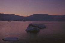
|
|
|
|
|
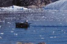
Motorboat
with a kayak resting on
the gunwale |
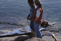
Lars Jensen
preparing to launch |
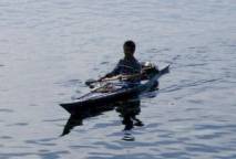
Lars
paddling |
|
|
|
|
Lars
accelerating note stern is
pulled under |
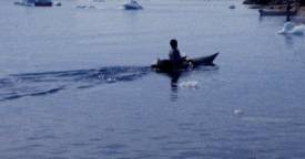
Lars
Jensen throwing Float off
stern |
Nikolaj showed me that he measures
the length for the foot to the back by bending the feet back as far as
comfortable with the heels together with the legs straight out and the feet
splayed in a V to the sides rather than straight up.
The
height of the cockpit above the knees is planned so that the knees will be bent
slightly upward to firmly touch the knee support cross beam, seeqqortarfik
ajaaq, with the feet to be extended forward pressing against the foot support
cross beam, tukerumiaq ajaak during rough water conditions and the knees must
be well braced to execute the roll.
This
does not take into account the distance between the kayaker's buttocks and the
back support cross beam, isserfik ajaaq which I am not sure about. Probably the kayak paddler is sitting firmly
against this crossbeam to maintain sufficient leverage.
Neils
Møller said that the paddler is measured with the feet pressed back and the
legs straight out.
Lars
Jensen said that the distance is measured with the feet straight up and the
legs straight out.
The kayak paddler sits with his feet
splayed in a V to the sides rather than straight up. This is one of the physical discomforts that a Greenlander must
adapt to for kayak paddling.
I
noticed that many kayak paddlers are bow-legged. I am not sure if this is caused by physical deformation created
by the long hours in the kayak or if it is nutritional.
In Kullorsuaq the Narwhal whale is
easier to hunt by kayak because the silence of the kayak allows the hunter to
approach more closely. The paddle is
designed to have a very well finished surface finely sanded to not drip water. I saw two varnished paddles.
I took measurements of the white
kayak used by Nathanial Jensen.
Reference for kayak parts is
available in the book Instruction in Kayak Building by H.C.Petersen
published by The Greenland Provincial Museum / the Viking Ship Museum in
Roskilde.
Nikolaj showed me two pictures in
the 1987 paperback edition of Skin Boats of Greenland which had two photographs of him in his kayak.
Skin Boats of Greenland by H.C.Petersen and Hans Ebbesen,
published by Arkrisk Institute number 3 1987 ISBN 87-980676-9-9 at Brunnsvej
10, 2920 Chaarlottenlund, DENMARK.
I
happened to find and record by camera and video two enlargements of those Jette
Bang photos hanging in the school.
A publisher in Nuuk, which publishes
many books about Greenland is Atuakkiorfik, POB 840. 3900 Nuuk, GREENLAND
phone: 011-299-22122 and fax: 011-299-22500.
Greenland tourism A/S Hans Egedesvej 29, POB 1552, 3900 Nuuk phone:
011-299-22888. Greenland Rejsebureau,
POB 330, 3900 Nuuk phone: 011-299-24455 fax: 011-299-23369.
I collected some plants in the area
near the telecommunications tower which was 1/4 mile north of the position that
my GPS indicated as being 74 34.85'N, 57 13.35'W I am not at all
sure of the accuracy of this reading because the map indicates
differently. I gathered plants mostly
on low nutrient dry gravel. The lichens
are: Cladonia amaurocrocea celotea w/cups, C. fimbriata, Aletoria Ochroleuca,
Cetraria delisei, C. ericetorum C. nivalis, Sorolina crocea, steoeocualon
paschale, S. glareosum, Xanthoria elegans, cornicularia divergens, black blobs
over very wet rock. Solorina crocea,
Cetraria andrejevii growing with Cladonia amaurocrocea and Stereocaulon
Glareosum. The vascular plants are Salix
herbacea, S. cordifolia var. callicarpea,, Empetrum nigrum, Pedicularis
hirsuta, Diapensia lapponica, Silene acaulis ssp. acaulis, Stellaria Edwardsii,
Vaccinium uligiginosum var. uliginosum, Cassiope tetragona ssp. tetragona,
Dryas integrifolia, Papaver radicatum, Draba nivalis, D. corymosa, D. lactea,
Polygonum viviparum, and Saxifraga
cernua. The grasses were Phleum
commutatum in town where the soil is rich and damp. On the south facing slope
the grasses were Poa arctica ssp. caespitans, Carex arctogena, Carex atrofusca,
and Festuca baffinensis. In wet soil on
the north facing slope I found Lycopodium annotinum.
The birds I saw were Arctic terns,
Glaucous gulls and Northern fulmars.
Butterflies were Artic fritillary,
green- gray common one, grey skipper type.
Epilobium latifolium has edible leaves
which people strip from the stems and mix with seal oil as a salad.
Reference for fungi in Greenland is
- Pupit Kalaallit Nunaani by Torbjorn Borgen published by Atuakkiorfik,
POB 840. 3900 Nuuk, GREENLAND phone: 011-299-22122 and fax: 011-299-22500 in
1993 ISBN: 87-558-0889-1.
I collected on July 19 some
mushrooms which were a Russula altaica, Omphalina hudsoniana and a Russula
chamiteae.
I visited for a short time with
Rigitze Sabye because she has spent more than twenty years studying the Inuit in
Greenland. She is about to publish a
book, which compares the old life with the modern life of these people. She is visiting Kullorsuaq to collect
information this summer and then when she returns to Denmark she will write.
|
|
|
|
|
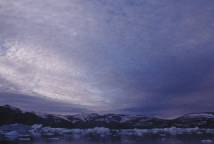
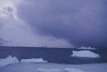
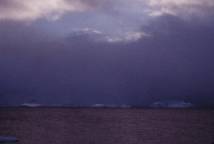
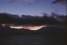
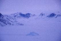
alto
cumulus clouds over Holm
Island |
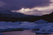
mass of icebergs
driven in by
strong storm |
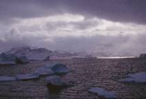
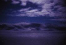
Cloud
break in complex storm
September |
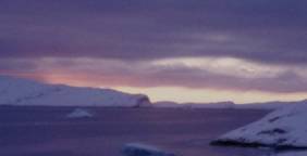
|
|
|
|
10/10/95
Gail Ferris paddling
Klepper |
Storm
front approaching between
Holm Island |
9-3-95
15:22 1016 mb powerful low pressure winds SW at15
knots pushed ice right into Kullorsuaq making boating debarkation difficult
heavy rain and fog visibility 1 nautical mile
18:00 1018 mb
19:30 1018 mb
9-4-95
15:00 1018 mb cleared up slightly calm fog rolling
in from above light density on top of Holm Ø
9-6-95
warm temperature with partial low ceiling half way across sky light rain
stratocumulus temp warm -7 °C
9-7-95
07:00 1023 mb dense fog starting to lift 0 C
9/4/95
When we had a storm the other day I was surprised
to see a large number of icebergs pushed up on shore. Those icebergs delayed the arrival of a boat from Upernavik for 3
hours because the boat had to wait for the ice to move away from the pier
before they could come in.
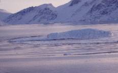
|
|
|
|
|
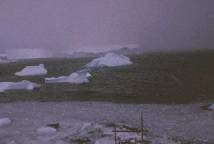
fierce
wind storm note
all the small chunks of ice in
foreground |
ferry
Angua Ittuk fish
factory in background |
Holm
Island being occluded
by adv squall |
|
|
|
|
Iceberg
rolling over Happens
any time The water
is open |
late day
sun in October blue
foreground |
10-4-95
overcast mixed clouds altostratus, altocumulus and
stratostratus snow on the ground, open water no ice; 100 beluga whales caught
mattak/whale skin in ½ meter squares brought in by boats and unloaded at the
pier taken up to the factory for processing and freezing. Glaucous gulls Laurix glauca
10-10-95
Clear
day reflected light dominant visible color blue with the color of the water
blue indigo, brown colors in the rocks on Holm Island clearly visible, quiet
water wind less than 5 Kts, orange yellow light, clear cirrostratus and
altostratus 10-11-95
08:30 sunrise overcast day no cloud definition grey
day chunks of ice brought in by the southwest wind.
10-12-95
09:15 sunrise with a mixed sky. Glaucous gulls
diving but they looked white and had black feet which Ivory gulls have. They were diving and also eating food after
they landed on the ice chunks.
10-15-95
snow squall 4 nm away between Holm Ø and Saadlia Ø
coming in from the west strong wind sheer on the water indicating +25 knots of
wind gusts, 20 minutes later the squall hit.
10-16-95
25% of horizon visible at sunset
09:00 Sunrise with strong light to
the east but cloudy to the west altocumulus 70% cloud coverage grey light, no
stratus layer clouds
10-18-95
9:30 +25 knot squall coming in but opening to blue
sky though cloud cover. The squall is
working its way in, turning the blue indigo water to silver black and blue.
12:30 The front coming from the west
came 4 nm in 5 minutes from 12:30 to 12:35.
Openings in the sky are common when squalls come to Kullorsuaq.
15:53
Sunset with alto or cirrostratus on southern horizon
10-20-95
The sun at 11:00 this morning Friday October
20th is clearing the horizon at a scant 1 however the altitude of this
horizon four miles away is in the 2000 foot range so from here the actual
height of the sun is 4 . On a
clear day such as today the snow is blue in the shadows and white with a tinge
of golden yellow. The icebergs most
commonly tend to be a turquoise blue blending to white with transparent bands
of turquoise blue in them here and there.
Often the sky when it is cloudy will be purple
and the icecap is usually a strangely luminous pastel pink, purple, turquoise
undulating white. The height of the
icecap is strange to see because the icecap covers all of the peaks with just a
few rare exceptions. These peaks that
protrude though the icecap are called Nunataks. They are islands of solid hard rocks often some sort of
granite. When I look at the icecap it
is the highest elevation to the east and it looks like it is something not
really solid and then again it looks incredibly solid but it also seems to be
just hanging in the sky. The icecap
reflects the light from the clouds back into the clouds. This reflection back and forth between the
clouds and the icecap and the way this compressed snow absorbs and reflects
light gives the icecap this unreal appearance.
In summer bright light conditions the icecap has this strange glow to
it.
For
me just to see how the light changes as the sun becomes lower and lower is very
exciting. The red spectrum of light
gives way to the blue spectrum as the light diminishes.
Half
moon shows brilliant in the very clear conditions with 5% cloud. The water has a coverage skim of ice,
because there is only a 5 knot wind.
|
|
|
|
|
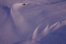
dark pink purple blue light |
snow
shapes sculpted by the wind |
Noon on a
late November day during
the Dark Time/Winter |
|
|
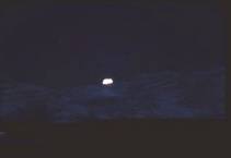
|
The moon
over Holm Island November
dark time |
10-21-95
golden sunrise showing blown out altocumulus and stratocumulus with scud on
Holm Ø orographic clouds ¼ above horizon with a small area stratus layer
setting top of Holm Ø. Lars and Hans
Jensen return in their motorboat with a 5 meter beluga.
10-22-95
10:25 sunrise pink light altocumulus 40% cloud
cover, wind 10kts, whale hunters at the pier with mattak and the Anja Ittuk was
unloading. Mixed alto and stratocumulus
with scud blowing in purple sunrise of reflected light wind 10 knots.
10-23-95
10:30 clear absolutely pastel blue and pink but
there is a front off to the south west with a solid wall of dark grey clouds
covering to a height of 1% of the horizon.
Interesting that both the water and snow are the same color to the
eye.
14:00 Sunset at 14:00 stratocumulus, altostratus as
a solid wall to the southwest which has advanced to cover 3% of the horizon.
And altocumulus and stratocumulus are showing up in advance.
10-24-95
10:00 sunrise mixed clouds rays of the sun are a
fan. 40% cloud density in the easy with weak alto and cirrostratus
crisscrossing some cirrocumulus but it is clear overhead. Lars and his father Nikolaj Jensen coming in
with their boat filled with about 12 seals never saw two hunters return with
such a huge number of seal as that before.
It looks like Lars and Nikolaj haven’t lost their touch.
Now, on October 24th. at
latitude 74 N the sun rises at 10:00 because of the local topography and
the sun sets at 3:00 or 15:00. The
twilight, which occurs over the water lasts until 6:00 or 18:00.
10/24/95
We are getting snow in small amounts every so
many days. It has become nice and cold
up here about 15 F and now walking on the snow is not much of a problem
because the traction is quite good.
Occasionally there is a slick spot here and there but it is not as
difficult as when the snow fell and the temperature was just at freezing. Walking was very slippery then.
The light on the snow is very interesting and
I have some good video shots of that.
What is really strange is
to go for a walk in this oblique but completely clear light because the light
shines under the bottom areas of bridges through any sort of tunnel and into
the bottom undercut areas beneath boulders.
So I can look at things that usually are never in the light.
Some of the minerals on
the rocks show up in much more interesting ways with this type of light,
especially if it has a slight orange tinge to the light.
When I go for a walk to
places I have been many times before, everything looks entirely different and
often much more interesting in this strange light.
Today the sun rose at about 10:00 and set for
a moment at 2:00 now I can see it just on the horizon behind some clouds and it
is 3:00. Now at 3:30 the back lit
mountain to the west has turned blue purple.
The light is clear the water has tiny waves that are gold flecked with
light blue and dark blue. The water is
reflecting the sky and the mountains on the islands at its edges. The snow cover on the tops of the mountains
and across the saddle back ridges is reflecting the blue sky and the clouds
behind are pale blue blend upward to yellow white. I almost can't tell where the top of the snow cover ends and
where the cloud cover begins.
And yet there has been wind not much
wind just 10 - 15 knots everyday so the water has not started to freeze even
though it is cold enough to easily freeze.
Once the wind stops the water will just freeze solid instantly
10-25-95
09:00 behind the 840 meter peak on Holm Ø is a sun
pillar altostratus and thin cirrus clouds.
15:15 - 20% cloud cover pastel sky, ice edge
extends 2 to 3 meters into the water and is submerged very likely fresh water
runoff which freezes at a higher temperature than salt water.
17:00 twilight mixed sky of altostratus and cumulus
35% coverage dense altostratus with clear openings altostratus and cumulus with
Virga patches
10-26-95
09:00 pink reflected light in both the sky and
water. Altostratus 20% of the horizon blown out crisscrossing along the
southern horizon from the east to the west sky is pink to 10% of horizon then a
darker layer to the west
10:00 pastel reflected pinks definite crisscrossing
altostratus suggesting strong low altitude winds off the icecap to the east and
strong high level winds from a storm approaching from the southwest but
actually it is just the low level sun making cloud shadows.
12:00 heavy altostratus 70% density viewed from the
top of Kullorsuaq Ø wind less than 5 kts.
Interesting phenomena of very yellow light reflecting for a short moment
off the icebergs 4 - 6 miles to the north in Melville Bay but the light changed
quickly to pale -white before I could really capture it with it’s full
intensity on video. Recorded snow to
show large plate crystal conglomerations and wind drift configurations around
the rocks.
15:30 sunset orange with 10% horizon
occluded by a defined thin layer of cirrostratus, altocumulus and stratocumulus
and the sky was clear overhead.
10-31-95
11:00 open sky with altocumulus
showing orange yellow light on the stratocumulus on Holm Ø
Throughout
the October the temperature was often minus 15 but with wind mixing on
alternate days sufficient enough to prevent ice formation.
11-3-95
no sun just pastel luminescent pink,
purple and blue colors with the
icebergs in turquoise. Cirrostratus and
virga open sky here and there but 80% cloud coverage later there was a big rain
storm and November was to be an unusually warm month.
11-4-95
08:00 skim ice dead calm
12:48 pale colors with extensive
virga. Altostratus lending into the
stratus layer with wisps of stratocumulus blown out becoming stratostratus,
high cirrocumulus dominance of stratus with stratocumulus and scud thin cloud
density 15% sky this was just a day after a big rainstorm. Wind 5 knots pastel
blue, grey and white colors purple is dominant with yellow pinks, blue-grey sky
and yellow.
11-8-95
04:00 strong squalls generating 1
meter waves and bringing in ice chips.
10:05 storm coming in. Occluded western horizon solid with
stratocumulus sun lit up altocumulus scud 90% cloud cover altocumulus. Visibility less than 1 mile.
12:50 stratocumulus directly south
on Holm Ø at the top of the 780 m peak pink against purple white opening up to
altocumulus with blue sky.
11-9-95
November 9th,
1995
It's another fine day in the Arctic right now
it is 12:48 our local noon on November 9th, to be exact.
We had this most interesting sun
illuminations of the clouds in the east around 10:00 earlier the clouds in the
sky were these elongated altostratus or extremely blown out altocumulus clouds
very stretched out lenticular shapes in tones of blue grey with some yellowed
blue grey in the open areas of the sky.
Then around 10:00 the
colors of the undersides of the clouds changed to a deep purple grey. At around 10:30 these purple grey clouds had
scarlet pink edges on their bottom edges, which was reflected sunlight. The sun is now below the horizon all
day.
At 11:30 the sun has now
moved to the south and the concentration of clouds to the east had
dissipated.
Now there were only thin
remains of altostratus clouds in very pale pink against a pale yellow blue
sky. At 12:00 there were now clouds on
the south horizon and few if any clouds on the east and west horizons.
The wind had started to show at 10:30 as 10
knots generating 1/2-foot short cadence seas coming from the east. Just as I sat down to start my letter to I
could see dark water two miles to the south and there shown a particularly definite
line demarking where this dark water was.
Such highly defined dark
water indicated that some very strong wind is beginning to blow. This line of demarcation between dark
turbulent water and gray calmer waters indicates that a very strong wind is just
starting to set in but for the moment the wind is being forced to follow the
local topography being funneled by the mountains on the islands.
As the wind becomes more
established this line of demarcation will dissolve and the strength of the wind
will equalize throughout most of this area.
Where the wind will be weakened is where it forms back eddies against
opposite rises in topography such as steep hillsides and very protected coves.
The waves at 13:15 are no longer those little
1/2 foot waves, now they are 3, 4 and 5 foot waves coming in close
succession. There are cats’ paws here
and there on the water where especially strong gusts are hitting the
water. The icebergs are once again on
the move, reshuffling themselves and moving out into the open waters from where
they calve from the glaciers of the icecap.
Going by ship back and forth on the 150 mile
run to Upernavik will be especially challenging today and tomorrow. I don't envy the guys handling the
ships. The Iput is at the dock
right now and soon they will head back to Upernavik they only do 8 knots with
it and although she is a West Juteland very seaworthy design she loves to roll
like all deep vee rounded cutter hulls do.
It's going to be a rough trip back for them down to Upernavik. We do have a couple of harbors of refuge
here and there but they can't just go hide when the going gets a little bad
when they are running a commercial vessel.
The
ice tried to form after several weeks of -10 and –15 C but for the last
few days has been so warm that the west Greenland current has once again had
it's chance to warm the water up.
12:00 dense orographic clouds of
blown out altocumulus with regular altocumulus fractured. Some holes in the sky. Water shows wind of 5 - 20 knots 1 foot waves. Wind from the sought east coming off the ice
cap open sky here and there with dark grey fractured altocumulus
15:00 interesting combination of
altocumulus lots of Virga and scud. 15%
sky coverage opposite cirrocumulus that are the remains of a big storm herring
bone cirrus lots of wind blown out clouds
11-10-95
11:21 Nasty storm 1½ to 2 m waves
wind +25 knots from southwest whitecaps and rooster tails 100%cloud coverage
scud racing by overhead. Altocumulus
and stratocumulus massive inundation of ice packed solid for 100 feet off
shore. Very high tide washing out boats
etc about 1 ½ met above normal high time level. Snowing visibility ½ nautical mile 4 nautical mile fetch of 4 nm
with 2 meter waves from SSW brought in huge icebergs off the town pier west of
my house.
Now I am writing to you on November 10th at
14:00 or 02:00 pm and I must tell you that a very strong storm has set in. Not only are the winds a consistent 30 - 35
knots but there are higher gusts and as I might expect the seas have become
huge and fierce. Right now things are
starting to cut loose and anything such as boats not sufficiently well secured
is cutting loose. All sorts of objects
are washing out from shore - steel boxes, ramps, docking equipment, lumber
boats that had only been pushed up but not tied off are among the uncountable
chunks of ice.
The waves are two meters or 6 feet high
rolling through the ice chunks just as if they weren't there. Icebergs are breaking up and washing into
the coast as far as they can until they ground out.
Entire families not just brothers
and sisters with their children but even cousins are down on the shore dragging
the heavy fiberglass 16 foot motor boats up as high as they can. Everyone is heaving on the lines to bring
their boats up above the reach of these roiling ice chunk filled waves.
I did not make any trip to the post office or
the store today because the wind and the icy walkway are too dangerous.
When I was writing you yesterday the wind
never became especially intense maybe it was 20 knots out in the open areas
directly down wind but as the afternoon wore on the wind gradually
diminished. By evening it was quite
calm but Hans did tell me that they were expecting a storm coming up the coast
from the south. I had thought that
these winds which we had at 04:00 in the morning on November 9th or yesterday
morning and around noon on that same day were from that storm. Well that certainly was not the case.
November 10th
Now at 20:00 or 08:00 in the evening on
November 10th it is finally calming down but I would not be surprised if this
calm is probably just for the moment while the tide is changing. The temperature has finally gone below
freezing but the storm has left all the walkways through out town thoroughly
iced over.
The morning was calm no crashing waves at
08:00 but by 10:00 the waves started coming in with renewed energy. It was very warm and the wind was blowing
out of the south at a solid 15 - 20 knots.
The sky all this time was a solid grey of altocumulis clouds with a
break in the cloud cover through to clear blue sky fringed by puffy silver
clouds directly overhead.
As I had seen so many times before when there
are holes in the sky that means the exact opposite of clearing conditions. Here holes through the ceiling means strong
winds and nasty squalls.
It was so stormy around noon that
parents refused to let their small children out of their houses to go to school
11-12-95
13:18 overcast purple-grey light and cumulus clouds
11/14/95
We just experienced the worst storm anyone
can remember for the last few years.
The storm had strong winds with I suspect some 40 knot gusts and a
sustained 30-35 knots of wind for 6 hours at a stretch. Several boats washed off the rocks and
others left in the water turned over and were smashed to pieces by the chunks
of ice driven in by the wind.
The next settlement to the south,
Nussuaq faces south with a large exposed pier.
The wind drove some icebergs against the pier which were so large that
these icebergs destroyed half of the pier and the KNI store that was on the
pier and knocked out the supply of electricity
I'm having just the most exciting time
watching the colors change in the sky, on the water, on the snow covered
mountains and on the icebergs. The sun
has now dropped below the horizon for the next three months but there is still
plenty of reflected light that is almost as bright as direct sunlight the major
difference is that there are no shadows.
There is a very long twilight I haven't actually really measured it's
length but I estimate that it is about 4 hours.
11-23-95
frazzle ice against the shore wind 10 knots 2 ft swells
12/1/95
We had some impossible ice here that I could not
walk on.
going
to the store. You certainly saved the
day for me. I went out for a nice walk
on the metal frame ones places nobody else could possibly go and I had a nice
time looking at the winter snow on the plants and taking a look at Melville Bay
from the north side of this island.
Sometimes I have seen huge icebergs out on Melville Bay because the
icecap breaks off large icebergs into this bay. The icebergs can be several miles both long and wide but not as
high as the icebergs
|
|
|
|
|
moonlight
among clouds Dec
95 |
Christmas
day moonlight
95 |
moonlight
January |


|
|
|
|
Kullorsuaq
Arctic Haze –30 C
dog sled tracks |
south of
Holm Island photo
taken from helicopter 2 29 96 |
The measurements of the white kayak
used by Nathanial Jensen is measured directly along the kayak.
The
length along the top of the deck is 539 cm
The
masik to the rib on the inside is 18 cm and the rear cockpit deck beam to the
keel depth is 14 cm. The diameter
inside the cockpit side to side is 42.5 cm and front to back is 46.5 cm. The cockpit was designed for a right handed
hunter because the outside measurement of the cockpit to the outside edge of
the deck is offset on the left side it is 4.5 cm and on the right side it is
9.5 cm.
The
distance along the keel from the bow to the last nail on the rise 91 cm, then
from that nail to the 1st deck strap 31 cm, from the 1st deck strap to the 1st
rib 71 cm, the depth keel to gunwale is 24 cm, the length bow to deck strap
along the deck is 91 cm. (?)
Starting
at the bow along the deck the widths are at the tab for the gun 8 cm which
distance 59 cm from the bow, width at the front or 1st deck strap 14 cm, width
at the straight or 2nd deck strap is 52, at the aft end of the diagonal or 3rd
deck strap is 57 cm, width in front of the cockpit is 58.5 cm at the middle of
the cockpit is 58 cm, at the back of the cockpit is 56 cm, at the 4th deck
strap just behind the cockpit is 51 cm, and at the rear or 6th deckstrap is 16
cm.
The
inside dimensions are masik to rear deck beam 46 cm, the inside width at the
top of the left gunwale to top of the right gunwale at mid cockpit inside is
54.5 cm, the inside width at the bottom of the left and right gunwale is 51
cm. The dimensions of the wood used for
the gunwales is 1.75 cm by 7 cm.
The
ribs are made of plastic about 1 cm thick.
The
skeg is made of white plastic and is attached to the boat with line going
through hole drilled into the keel.
This skeg and all the skegs on Nikolaj Jensen's kayaks are attached in
the same manner as the Geisler kayaks in Upernavik. The length of the skeg is 25.5 and the height is 10 cm it is located
29 cm from the peak of the rise in the stern.
1st
rib from the keel to chin 15.5 cm, 1st rib from chin to bottom of gunwale 22.5
cm, 1st rib from the bottom of the gunwale to the top of the gunwale 30 cm, 1st rib across the deck 36 cm, 1st rib distance along the keel to
the 2nd rib z cm,
2nd
rib from the keel to chin 17 cm, 2nd
rib from chin to bottom of gunwale 25
cm, 2nd rib from the bottom of the gunwale to the top of the gunwale 32 cm, 2nd
rib across the deck 44 cm, 2nd rib distance along the keel to the 3rd rib 26
cm,
3rd
rib from the keel to the chin 19 cm, 3rd rib from chin to bottom of gunwale 27
cm, 3rd rib from the bottom of the gunwale to the top of the gunwale 34 cm, 3rd
rib across the deck 50 cm, 3rd rib distance along the keel to the 4th rib 24
cm,
4th
rib from the keel to the chin 20.5 cm, 4th rib from chin to bottom of gunwale
20.5 cm, 4th rib from the bottom of the gunwale to the top of the gunwale 35.5
cm, 4th rib across the deck 53.5 cm, 4th rib distance along the keel to the 5th
rib 21 cm,
5th
rib from the keel to the chin 21.5 cm, 5th rib from chin to bottom of gunwale
29.5 cm, 5th rib from the bottom of the gunwale to the top of the gunwale 37
cm, 5th rib across the deck 57 cm, 5th rib distance along the keel to the 6th rib
20 cm,
6th
rib from the keel to the chin 22 cm, 6th rib from chin to bottom of gunwale 30
cm, 6th rib from the bottom of the gunwale to the top of the gunwale 37.5 cm,
6th rib across the deck 60 cm, 6th rib distance along the keel to the 7th rib
18 cm,
7th
rib from the keel to the chin 22 cm, 7th rib from chin to bottom of gunwale
30.5 cm, 7th rib from the bottom of the gunwale to the top of the gunwale 38
cm, 7th rib distance along the keel to the 8th rib 17 cm,
8th
rib from the keel to the chin 22 cm, 8th rib from chin to bottom of gunwale 30
cm, 8th rib from the bottom of the gunwale to the top of the gunwale 38 cm, 8th
rib distance along the keel to the 9th rib 17 cm,
9th
rib from the keel to the chin 21 cm, 9th rib from chin to bottom of gunwale 29.5
cm, 9th rib from the bottom of the gunwale to the top of the gunwale 37 cm, 9th
rib distance along the keel to the 10th rib 17 cm,
10th
rib from the keel to the chin 20.5 cm, 10th rib from chin to bottom of gunwale
28.5 cm, 10th rib from the bottom of the gunwale to the top of the gunwale 35
cm, 10th rib distance along the keel to the 11th rib 17 cm,
11th
rib from the keel to the chin 18 cm, 11th rib from chin to bottom of gunwale
25.5 cm, 11th rib from the bottom of the gunwale to the top of the gunwale 33
cm, 11th rib distance along the keel to the stern 23 cm,